Is it still worth knowing how to read a mountain map in the new digital era? What if you would understand the importance of paper maps? Would you start hiking using maps afterward?
With so many digital devices, it may seem unimportant at first glance, but knowing how to read a map can make a difference in having a pleasant and relaxing time in the mountains.
Many years ago, as I went hiking in the mountains with my family, I always admired my father because he carried a map. I remember the first time I held a map in my hands, and I was overwhelmed by all the details that were written on it—green, brown, grey, blue, or black. Little did I know back then that everything had a meaning.
Time passed, and only after taking the mountain guide course did I finally understand how valuable this skill can be and how easy it can be to hike or navigate in the mountains using only “a piece of paper.”
Would I recommend spending some time understanding how to use a map?
Yes, yes, and again, yes.
Actually, I will give you 6 good reasons to understand how everything works, and if you read until the end, I will also describe the main characteristics of a topographical map.
- Navigation: Mountain terrain can be complex and challenging, especially off-trail. A map helps you understand your surroundings, locate key landmarks, and plan your route effectively. It would be sad to miss an essential point from your day or hike in the opposite direction. Not to mention how tragic it would be to miss the peak.
- Safety: Understanding a map’s terrain features and elevation changes can help avoid hazards such as steep cliffs, unstable slopes, or impassable terrain. It also lets you plan safer routes and make informed decisions while hiking or climbing. In that direction, I will later describe some general aspects of a topographical mountain map.
- Route Planning: A topographic map provides valuable information about the terrain’s elevation, contours, and features. This allows you to plan your route based on factors like distance, elevation gain, and difficulty, ensuring a more enjoyable and successful outdoor adventure.
- Emergency: In the event of an emergency, such as becoming lost or injured, if your phone breaks, the value of having a map becomes clear. It allows you to understand your location and even guide you back to safety or find alternative routes if necessary.
- Understanding the Environment: For outdoor enthusiasts who enjoy exploring remote or less-traveled areas, a map is indispensable for discovering new trails, peaks, and natural landmarks. It opens up opportunities for adventure and discovery while minimizing the risk of getting lost.
- Practicality: Do you need Batteries? Yes, you read well. A map doesn’t need batteries and can be used at all times. All you have to do is to remember to put it in your rucksack.
Even if you plan a day hike or an adventurous holiday, the ability to read a mountain map is practical and improves your enjoyment and safety in outdoor activities. Aditionaly, learning to read and interpret topographic maps is a valuable skill that fosters self-reliance, independence, and confidence in outdoor pursuits.
Living in Munich, a city less than 100 km from the mountains, I naturally want to spend as much time as possible outside hiking. In the end, this choice and direction permitted me to make a profession of my passion. That is why I recommend at least some minimal knowledge for anyone venturing into mountainous terrain, whether for recreation, exploration, or adventure.
If you were to visit Paris, for example, wouldn’t you have read something about the city before? Why not do the same about mountains? Hoping that it motivated you to read more, I will get to the second part and describe the details that lie behind almost any mountain map.
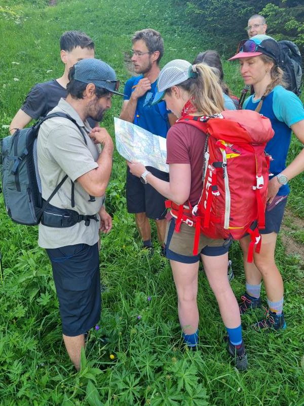
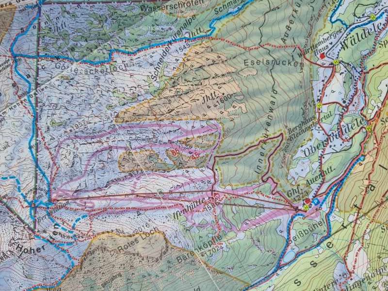
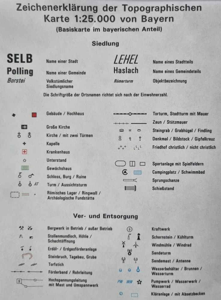
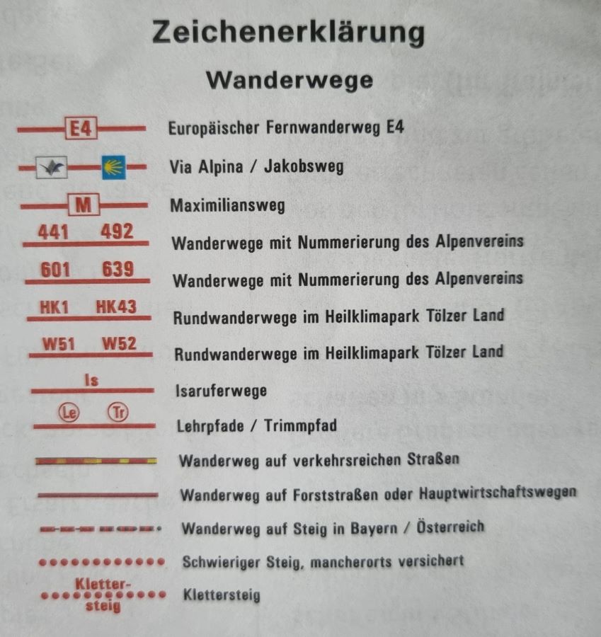
First, if you have a map, you must understand the symbols and legends. In the legend, all the essential elements are drawn as symbols and are described. Right from the beginning, search for the legend and begin by familiarizing yourself with the symbols used. These symbols represent various geographical features such as peaks, valleys, rivers, lakes, forests, roads, trails, contour lines, and others.
Second, identify contour lines. What do I mean by that? Contour lines are the lines connecting points of equal elevation on the map. They depict the height of the terrain and can indicate features like valleys, ridges, or slopes.
The vertical distance between contour lines is called the contour interval, and it’s specified in the map’s legend. The closer together the contour lines are, the steeper the terrain. Understanding contour lines helps you gauge the steepness of slopes and the shape of the terrain.
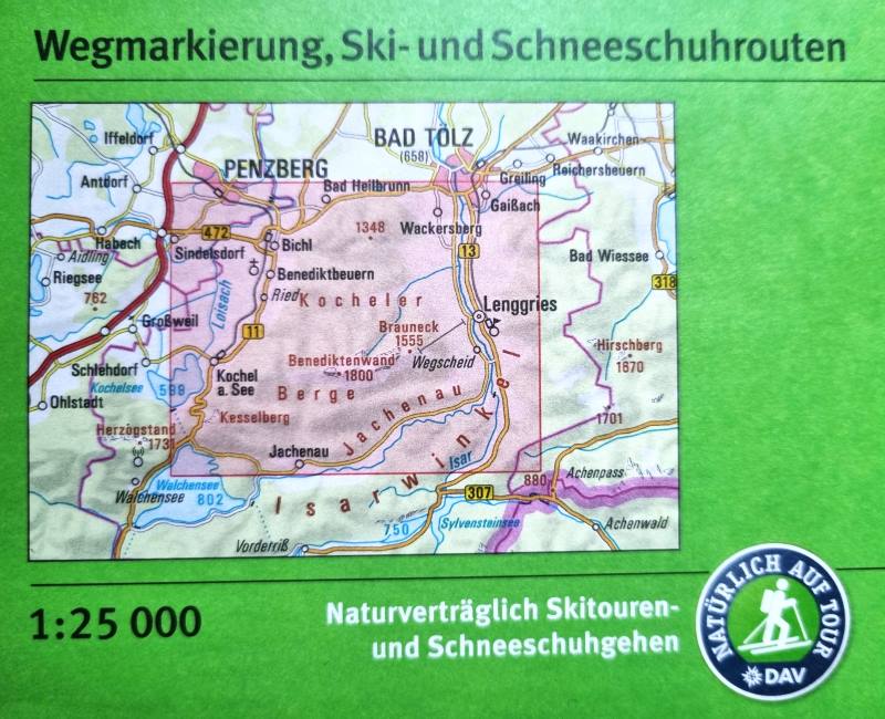
On German and Swiss maps from DAV(Deutscher Alpenverein), the distance between two lines is 20 meters, and in Italian maps, this distance is 25 meters. Also, this detail is written in the legend, so read it carefully.
Why is that good? If you have an altimeter(like a phone, for example), you can quickly tell your point on the trail. You can also identify the steepness of the surroundings, and in winter, you won’t get caught by any avalanches.
Now that you know about these lines, the next step is to orient the map: ensure you understand the orientation of the map. A north arrow or a compass can indicate this rose. Knowing the orientation helps you relate the map to the actual terrain. Look for prominent features on the map, such as mountain peaks, lakes, rivers, trails, or any other landmarks. These will serve as reference points to help you navigate.
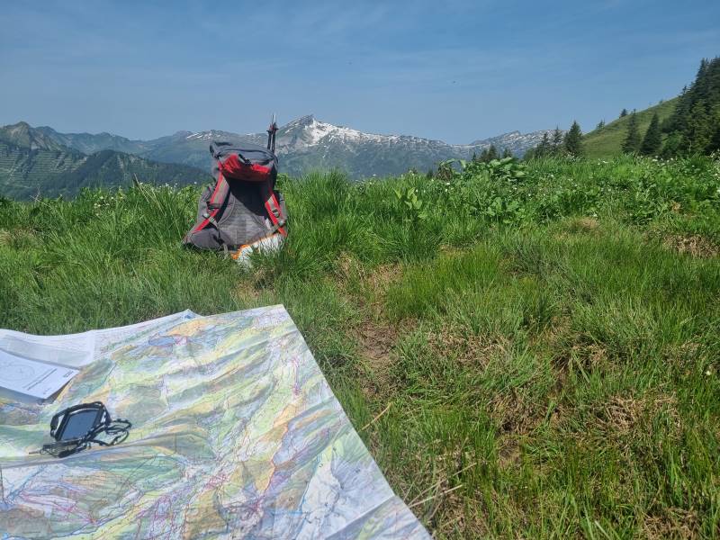
Each map has a scale: check the map’s scale and use it to estimate distances between points of interest or to gauge the length of a trail. This will help you plan your route and estimate the time needed for your adventure.
For example, on the DAV maps, the standard scale is 1:25000, meaning 1 cm on the map represents 250 m in reality, or 4 cm on the map represents 1 km. Only by knowing that you can estimate the distance of your tour.
If you’re familiar with using a compass, you can use it with the map to orient yourself and navigate the terrain more accurately. About the compass, I will write something in another article, because it is a more complex topic.
The Deutscher Alpenverein (DAV), or German Alpine Club, often uses the UTM (Universal Transverse Mercator) coordinate system for its maps. Additionally, another coordinate system, such as geographic coordinates (latitude and longitude), is also used. If you plan a trip in another place it’s best to check the map legend or accompanying materials to confirm which coordinate system is used in a particular map.
Every person who wants to start using maps needs to know that there are also two types: summer and winter. Summer hiking maps point clear trails, elevation, and water sources, focusing on vegetation and geological features. Winter maps with more information highlight snow-covered terrain and potential avalanche zones. These also provide recommendations for snowshoes, ski trails, emergency shelters, and alternative winter routes.
If you read that far, I encourage you to practice because only then will you gather experience and improve your ability to read and interpret mountain maps effectively. By doing so, hiking will be more safe and more enjoyable, and from now on, try also hiking using maps.
Go hiking, and try to use it more frequently, in addition to your phone and GPS